Severe Winter Storm Forecast for Central Plains and Mid-Atlantic: What to Expect
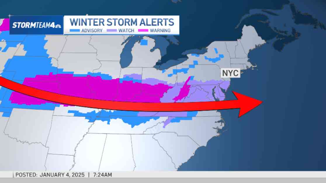
A major winter storm is on the horizon, set to bring heavy snow, significant ice, and frigid temperatures from the central U.S. to the Mid-Atlantic. According to the National Weather Service, the storm is expected to impact millions across the eastern two-thirds of the country.
Major Winter Storm Sets Up
The storm began its journey along the West Coast, with a large system bringing rain to the Pacific Northwest and snow in the Cascade Mountains. Meteorologists predict that this system will be the catalyst for a substantial winter storm spanning from the Central Plains to the Mid-Atlantic over the weekend and into early next week.
Snow to Fall Throughout Central Plains and Move East
By Saturday evening, widespread heavy snowfall is expected in areas stretching from central Kansas to Indiana, especially along and north of Interstate 70. Meteorologists anticipate snow accumulations of at least 8 inches (20.3 centimeters) in these regions, potentially marking the heaviest snowfall in over a decade for some areas.
The storm’s path will then lead to the Ohio Valley, where severe travel disruptions are anticipated before pushing into the Mid-Atlantic states by Sunday and Monday. With wind gusts exceeding 35 mph (56 kph) and heavy snowfall rates, blizzard conditions may develop, particularly in Kansas and surrounding areas of the Central Plains.
Freezing Rain Expected from Eastern Kansas to the Ozarks
In addition to heavy snowfall, dangerous sleet and freezing rain are expected from eastern Kansas to the Ozarks, posing threats to power lines and causing treacherous travel conditions. Areas accumulating more than a quarter-inch of ice may experience power outages as a result of the storm.
Meteorologists like Ryan Maue are warning that the upcoming weather event could lead to a potential disaster, urging residents to prepare for challenging conditions ahead.
Frigid Air from the Arctic to Blast Eastern U.S.
Following the storm, a blast of frigid Arctic air will sweep across the eastern two-thirds of the country, bringing dangerously cold temperatures and wind chills. Forecasters are predicting temperatures up to 25 degrees Fahrenheit colder than normal, with the potential for the coldest January in the U.S. since 2011.
Danny Barandiaran from the National Weather Service’s Climate Prediction Center highlights that the cold snap will extend southward, impacting areas as far as the Gulf Coast and even prompting a hard freeze in Florida. Climate experts like Jennifer Francis emphasize the severity of the impending wind chills, cautioning residents to brace themselves for brutal conditions.
Weather Triggered by Fast-Warming Arctic
The unusual weather patterns, including the cold outbreak, may be linked to a rapidly warming Arctic, underscoring the impact of climate change on extreme weather events. Climate experts like Judah Cohen warn that the polar vortex, usually confined to the North Pole, can extend to regions like the U.S., Europe, or Asia, inducing extreme cold spells.
As concerns over climate change grow, experts are emphasizing the need for increased awareness and action to mitigate the impact of such severe weather occurrences in the future.


