
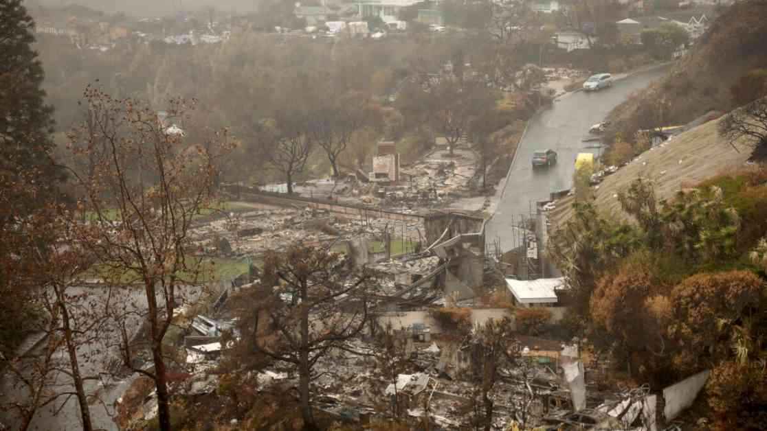
As Southern California braces for the most powerful rainstorm of the season, the looming threat of mudslides in the Pacific Palisades and Altadena burn areas has captured the attention of many. Following the destructive fires that ravaged these regions in January, reports from the California Department of Forestry and Fire Protection and the California Department of Conservation have painted a grim picture of the potential risks ahead.
In the aftermath of the Eaton fire that decimated over 9,400 structures in the San Gabriel Valley, a state report has highlighted a high likelihood of post-fire flooding and debris flows with heavy rainfall. Similarly, the Palisades fire in West Los Angeles has left the area vulnerable to flooding and rockslides, albeit with a lower risk of debris flows. Both reports underscore the significant additional damage that these burn areas could face in the coming years, serving as a cautionary tale for residents and authorities alike.
The looming threat of the impending storm was palpable during a news conference where Los Angeles County Supervisor Kathryn Barger urged residents not to take any unnecessary risks. As an atmospheric river began to move into the region, light showers were merely a prelude to the heavier rainfall expected on Thursday. The National Weather Service has issued warnings of potential debris flows and flooding, particularly in areas affected by recent wildfires.
Heightened Risks and Vulnerable Areas
As rainfall intensifies, the risk of mudslides and debris flows in burned areas escalates due to the lack of vegetation that once anchored the soil. The heat from the fires further compounds the issue by making it challenging for the land to absorb water effectively, leaving hillsides prone to erosion. According to experts, rain rates exceeding half an inch per hour could trigger catastrophic mudslides, jeopardizing homes and lives in their path.
Data from the U.S. Geological Survey paints a stark picture of the potential risks, with certain rainfall intensities carrying an 80% to 100% chance of generating debris flows in the Eaton fire area. Similarly, the Palisades area faces a 60% to 80% likelihood of debris flows, highlighting the imminent danger that residents in these regions are facing. With rapid escalation and minimal warning, the threat of flooding and debris flows is a cause for concern among authorities and residents alike.
Preparedness and Mitigation Efforts
In response to scathing criticism of their preparedness during the historic firestorms, Los Angeles County officials have been working tirelessly to mitigate the risk of flooding impacts. Clearing out basins, installing sandbags, K-rails, and compost filter socks, and planning to capture sediment on roads are just a few of the measures undertaken to safeguard vulnerable communities. Despite these efforts, some homes are expected to bear the brunt of the storm, necessitating evacuation orders in at-risk areas like Altadena and Malibu.
As the region braces for potential debris flows and flooding, the capacity of debris basins to contain mud, vegetation, and other debris is being put to the test. While the basins play a crucial role in mitigating hazards, there is a history of them being overwhelmed during severe storms, leading to catastrophic consequences. The lessons learned from past disasters, such as the Montecito debris flow in 2018, underscore the importance of proactive measures to prevent similar tragedies from befalling the region.
In light of the impending storm and the looming threat of mudslides, residents and authorities in Southern California are on high alert, taking every precaution to minimize the impact of potential disasters. With the risk of debris flows and flooding looming large, the collective efforts of the community are crucial in safeguarding lives and property from nature’s wrath. As the region braces for the deluge ahead, the resilience and preparedness of its residents will be put to the ultimate test, ensuring that they weather the storm with fortitude and determination.