
Winter Storms to Bring Snowfall to Tri-State Area
As the winter season progresses, several storms are poised to sweep across the East Coast in the upcoming week, bringing with them a mix of rain, sleet, ice, and snow. We can expect these storms to impact various regions, each with its unique forecast and implications.
Anticipating Snowfall Across the Tri-State Area
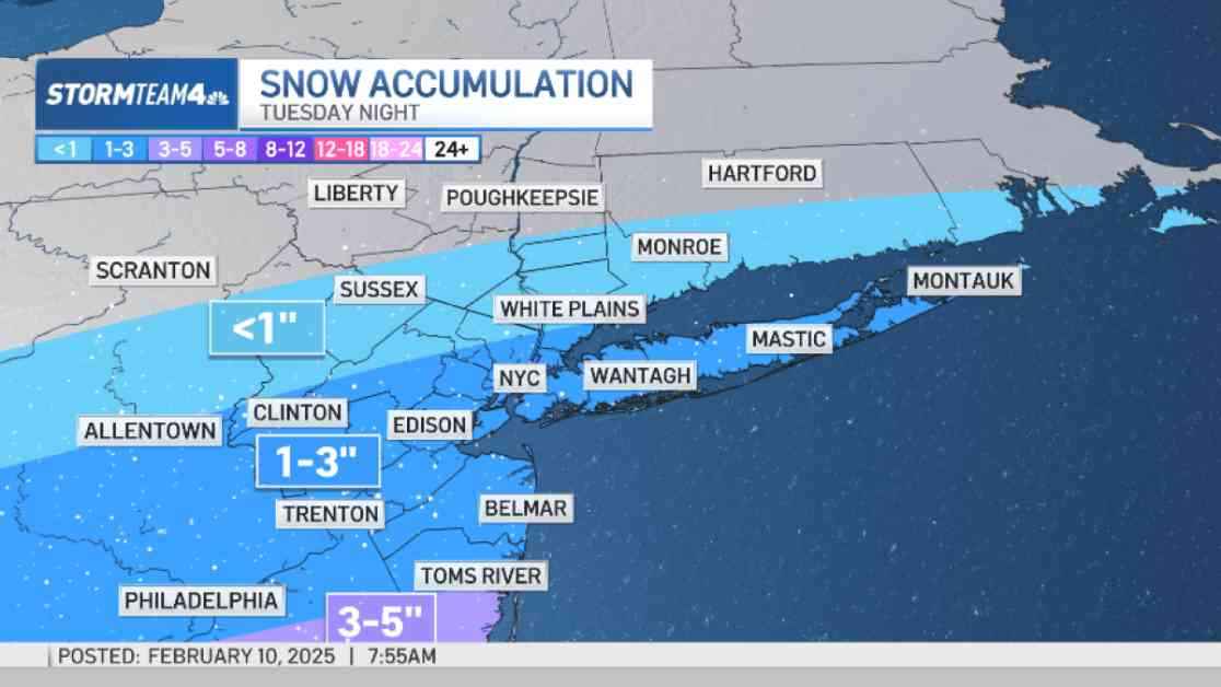
The next storm is forecasted to hit the Tri-State Area on Tuesday night, following a weekend with substantial snow accumulation. The snow is expected to begin after the evening commute, providing some relief for commuters. A Winter Weather Advisory has been issued for Monmouth and Ocean Counties, while a Winter Storm Warning is in effect from South Jersey to Virginia, West Virginia, and Kentucky. Residents are urged to stay informed about the latest weather alerts to prepare for the upcoming conditions.
According to the latest forecast from Storm Team 4, the heaviest snowfall from this system is projected to occur further south, as the storm will track below the Tri-State Area. New York City, Long Island, and lower parts of Westchester County can expect between 1 to 3 inches of snow, while areas in the Hudson Valley and Connecticut may receive less than an inch, with only a light dusting anticipated.
In New Jersey, Ocean County is expected to experience the most significant snowfall, with 3 to 5 inches forecasted. Central Jersey may receive 1 to 3 inches, while the northernmost areas of the state are likely to see an inch or less. The snow is predicted to fall throughout Tuesday night, with temperatures at or below freezing, leading to snow accumulation and potentially hazardous road conditions.
Multiple Storm Systems on the Horizon
Following Tuesday’s snowfall, additional storm systems are expected to impact the Tri-State Area throughout the week, bringing a mix of snow, rain, sleet, and ice. While the snowfall on Tuesday night is anticipated to clear up before the peak morning commute on Wednesday, another storm is set to arrive Wednesday night into Thursday, potentially causing more disruptions.
The second system may begin as snow, transition into a wintry mix, and end as rain on Thursday morning. Although light accumulations of snow and icy conditions are expected, areas north and west of New York City may experience higher snowfall totals. Commuters are advised to exercise caution on the roads, especially during the evening and morning commutes.
As the weekend approaches, a third storm system is forecasted to affect the Tri-State Area from Saturday afternoon into Sunday, with temperatures above freezing likely resulting in a rain event. While driving conditions may be less hazardous, the inclement weather could impact weekend plans. Additionally, there is a possibility of another storm in the middle of the following week, emphasizing the need for residents to stay updated on weather forecasts.
In conclusion, as winter storms continue to move through the Tri-State Area, residents should prepare for varying conditions, including snowfall, rain, and icy mixtures. By staying informed and taking necessary precautions, individuals can navigate the changing weather patterns and ensure their safety during challenging road conditions. Remember to monitor local weather updates and exercise caution while traveling to minimize the impact of these winter storms on daily routines and activities.