
This weekend in New York City, residents can expect a mix of snow, ice, and rain, making for a wintry Saturday and a sloppy Sunday. Winter weather advisories have been issued from Central Jersey up through the Hudson Valley, indicating potentially hazardous conditions. As the final installment in the series of East Coast storms, this weekend’s weather system is anticipated to have the most significant impact.
Early Saturday: Prepare for Wintry Conditions
If you have errands to run this weekend, it is advisable to complete them early on Saturday. The morning hours on Saturday will likely be the only window of dry weather before conditions deteriorate. With temperatures hovering below freezing across the region, the precipitation is expected to start as snow around lunchtime. Throughout the day, temperatures will remain constant until the evening, prompting a transition to mixed precipitation and ultimately all rain in and around New York City.
The change from snow to rain will likely occur first in South Jersey, transitioning to all rain by early evening, followed by a similar shift in New York City by mid to late evening. However, the Hudson Valley is expected to experience snowfall well into the night, with sleet and freezing rain mixing in later on. Freezing rain poses a significant risk as it instantly solidifies upon contact with the cold surface, creating hazardous icy conditions on roads, surfaces, and power lines.
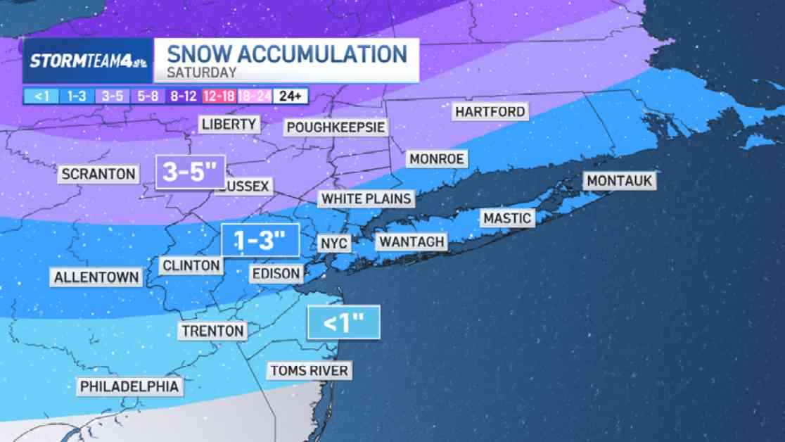
Ice accumulations in the Hudson Valley could reach up to one to two-tenths of an inch, potentially leading to tree damage and power outages. Typically, these issues begin to arise once ice build-up reaches a quarter of an inch. In regions with milder temperatures such as the Jersey Shore, snow totals are expected to be minimal, while areas like the city, Long Island, and northern New Jersey may see additional snow accumulation ranging from 1 to 3 inches. Northern locations could receive 3 to 5 inches of snowfall.
Sloppy Sunday Ahead
As Sunday progresses, rain is forecasted to be the predominant form of precipitation, melting much of the existing snow into slush. The day is expected to be messy, necessitating the use of rain boots. Some areas may even experience heavy rainfall in the afternoon as the storm system moves out, with the potential for thunder in South Jersey and Long Island. By the evening, the rain is expected to taper off.
In total, the combined rain, snow, and ice are projected to result in approximately 1 to 2 inches of liquid equivalent precipitation, with a significant portion falling as rain. While the timing of this weather system may disrupt weekend plans, the region is in dire need of the moisture due to ongoing moderate to severe drought conditions. However, the heavy rainfall may lead to isolated instances of flooding in low-lying areas.
Following the storm’s departure, the forecast indicates a couple of rain-free, sunny days at the beginning of the week. Nonetheless, this clear weather will coincide with a sharp drop in temperatures, ushering in a period of cold days with highs below freezing and mornings feeling like the teens or single digits. It appears that parka weather will be making a robust return.