
Weekend Weather Rollercoaster: From Rain to Snow
This weekend’s forecast is a rollercoaster ride of weather, with a warm surge followed by accumulating snow. If you’re a fan of mild winter temperatures, make the most of Saturday because the mercury is set to plummet next week. Along with the warmth, expect some patchy light rain, so keep your rain jacket or umbrella handy.
Saturday: Rain Showers and Cloudy Skies
Saturday’s rain will mainly be an afternoon affair, with the morning bringing overcast skies but little else. Showers will start making their way into the region around lunchtime and will have moved on by dinnertime. While the rain will be scattered and light for most areas, those on the eastern end of Long Island might experience steadier pockets of rain. Remember to grab an umbrella before heading out, or a jacket with a hood should suffice.
Most areas will see less than a tenth of an inch of rain, with Long Island expecting slightly higher amounts between a tenth and a quarter of an inch. Despite the rain, its impact is not expected to be significant.
Sunday: Winter Storm Watch and Snowy Conditions
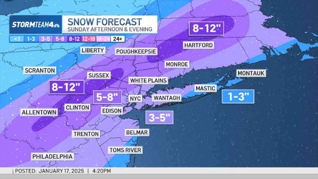
Sunday is the main event of the weekend, with a winter storm watch issued for northeastern New Jersey, the Hudson Valley, and Fairfield County in Connecticut through Monday morning. Snow will begin falling before noon as temperatures drop below freezing. With colder air moving in and favorable timing in the latter half of the day, most areas will experience below-freezing temperatures, resulting in an all-snow event. Snow is expected to start in the early afternoon, continue through the evening, and taper off after midnight.
Along the Jersey Coast and eastern Long Island, a mix of rain and snow is likely before transitioning to all snow, resulting in lower accumulations near the coasts. In the New York City metro area, 3 to 5 inches of snow are expected, while inland areas of northern New Jersey, upper Hudson Valley, and Connecticut could see 5 to 8 inches. Higher elevation spots in northwest New Jersey and the Hudson Valley might even receive up to a foot of snow.
Any changes in the storm track could impact snow accumulation locations, but the overall expectation is plowable snow across the tri-state area on Sunday. Prepare for shoveling and sledding on Monday but make sure to bundle up for the cold.