
Winter Storm Warning: Tri-State Braces for Biggest Snowfall in Years
The tri-state area is on high alert as weather experts predict a major snowstorm heading our way this Sunday. With warnings issued across New Jersey, New York, and Connecticut, residents are advised to prepare for potentially hazardous conditions as the storm rolls in.
What to Expect: Snowfall Forecast and Impact
According to forecasts, we can anticipate a significant amount of snowfall in various parts of the tri-state region. The New York City metro area is likely to receive between 3 to 5 inches of snow, while inland areas of northern New Jersey, upper Hudson Valley, and Connecticut could see totals ranging from 5 to 8 inches. Additionally, some elevated regions such as northwest New Jersey, the hills of Connecticut, and the northern part of the Hudson Valley may even experience up to a foot of snow.
The exact snowfall amounts will depend on the intensity of the storm bands, with some areas possibly receiving more snow than initially projected. However, coastal regions might see lower totals if colder air takes longer to move in.
Emergency Measures and Travel Advisory
In response to the impending storm, New Jersey Governor Phil Murphy declared a state of emergency on Saturday, urging residents to prioritize safety and avoid unnecessary travel during the severe weather conditions. Winter storm warnings will be in effect from 1 p.m. Sunday until 4 a.m. Monday for most inland areas, while New York City, Long Island, and coastal regions will be under a winter weather advisory during the same period.
The Metropolitan Transportation Authority (MTA) has assured that they are closely monitoring the situation but have not yet made any changes to their scheduled weekend and holiday services.
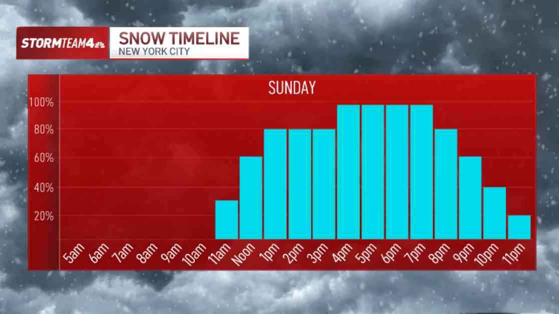
When and How the Storm Will Unfold
The snow is expected to begin lightly around 11 a.m. in the New York City area, gradually intensifying by early afternoon. Initially, rain may mix with the snow, especially near the coast, causing some melting and minimal impacts until 4 p.m. However, as temperatures drop to freezing from 4 p.m. onwards, travel conditions are likely to deteriorate rapidly.
The most severe weather conditions are anticipated between 5 p.m. and 9 p.m., with heavy snow bands potentially dropping up to an inch per hour. This could result in snow-covered roads and reduced visibility, posing significant risks to commuters and motorists. The snowfall is expected to taper off to light flurries between 9 p.m. and midnight, accompanied by a drastic drop in temperatures.
As the storm passes, the frigid temperatures will persist, leading to icy roads and hazardous travel conditions on Monday. Subsequent days will see temperatures plummet to the teens and 20s, with morning lows dipping to single digits in the city. Tuesday, Wednesday, and Thursday are forecasted to be particularly brutal, with morning wind chills possibly reaching sub-zero levels, creating dangerous outdoor conditions.
This winter storm serves as a stark reminder of the seasonal challenges we face, with January historically being the coldest time of year in Central Park. Stay safe, stay warm, and be prepared for the wintry blast heading our way.