
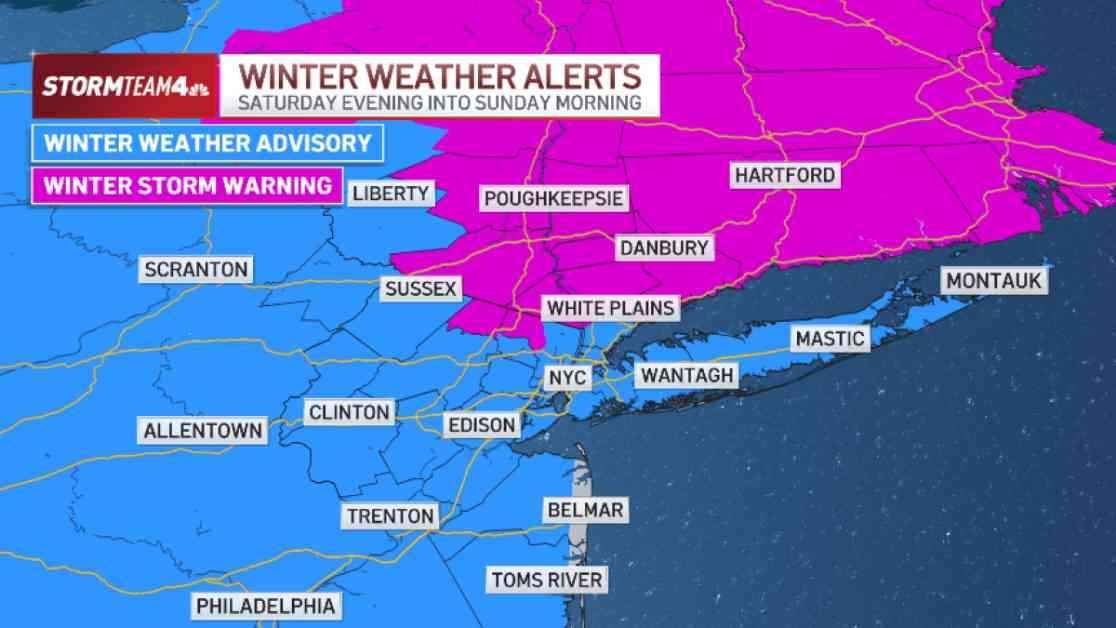
Snowstorm Set to Blanket Hudson Valley and Connecticut
A winter storm warning has been issued for various areas in the tri-state region, encompassing all of Connecticut as well as parts of the Hudson Valley. The impending storm is anticipated to unleash more than 6 inches of snow in regions situated to the north and west of New York City. Conversely, the remaining areas of the tri-state, including the five boroughs and the majority of New Jersey, fall under a winter weather advisory, with lower snowfall predicted.
Snowfall Projections Across the Region
Forecasts suggest that snow accumulations around New York City will likely range between 2 and 5 inches, contingent on the specific borough. Staten Island, southern Queens, and Brooklyn are slated to receive 1-3 inches, while Manhattan, along with the rest of Brooklyn and Queens, is expected to fall within the 3-5 inch range. Notably, parts of the northern Bronx could witness snowfall totals of up to 8 inches.
Moving towards the Hudson Valley, northern New Jersey, and vast portions of Connecticut, snowfall amounts ranging from 5-8 inches are projected. Central Jersey anticipates 1-3 inches, whereas Southern Jersey is likely to receive even less snow. The winter storm warning for areas north of New York City is scheduled to take effect at 5 p.m. on Saturday and remain in force until Sunday at noon. Concurrently, a winter weather advisory will be initiated for New York City, Long Island, and a significant portion of New Jersey during the same timeframe.
Anticipated Snowfall Schedule
The snowfall is expected to commence on Saturday night and taper off early Sunday, with daytime hours on both days remaining dry. This timing presents a silver lining in terms of minimizing travel disruptions, as heavy snowfall is projected when the roads are anticipated to be less congested. However, individuals with travel plans on Saturday evening are advised to proceed with caution, as road conditions are expected to deteriorate. The city of New York has announced the suspension of alternate side parking on Saturday to facilitate snow removal operations. The precipitation is set to begin as snow, with snowfall intensifying and a transition to sleet, possibly mixed with freezing rain, forecasted along the coast and south of New York City into early Sunday.
Potential Hazards and Precautions
Although ice accumulations in the tri-state region are expected to be minimal, untreated surfaces such as roads, sidewalks, and driveways may become exceptionally slippery. Therefore, exercising utmost caution while venturing out on Sunday morning is imperative to ensure safety. Despite the probable inconvenience caused by snowfall, Sunday holds the promise of being a delightful day for snow enthusiasts, particularly those not required to travel. Ready your sleds for some wintry fun!
Looking ahead, the weather outlook indicates additional opportunities for wintry weather in the latter part of the upcoming week. Stay informed and prepared as we navigate through this snowy season.