
As winter weather continues to grip the tri-state area, residents of New York City and surrounding regions are bracing for another round of snowfall set to arrive Tuesday night. Following a weekend of significant snow accumulation, the upcoming storm is predicted to bring lighter snow totals, providing some relief to those weary of shoveling and salting. Amidst the flurry of snowflakes and icy winds, the question on everyone’s mind remains: how much snow will this storm bring?
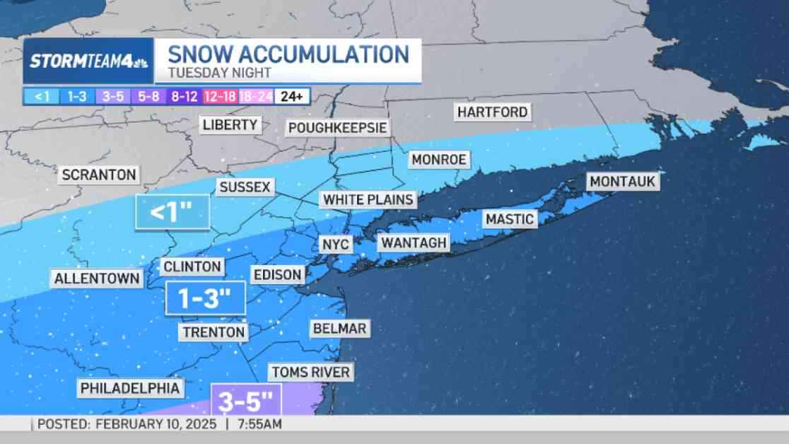
New York Snow Forecast for Tuesday
As the next storm system descends upon the region, snowfall totals are expected to vary depending on location. Residents of Long Island, the City, and North/Central New Jersey can anticipate 1-3 inches of snow, with lighter totals further north. The impending snowfall is poised to commence after the Tuesday evening commute, gradually blanketing the area in a shimmering white coat.
New Jersey Snow Forecast for Tuesday
In New Jersey, particularly Ocean County and areas south, snowfall projections are slightly higher, ranging from 3-5 inches with the possibility of localized higher amounts. A winter storm watch is scheduled to take effect at 1 p.m. on Tuesday, signaling the likelihood of increased snow totals in these areas. Fortunately, the storm is not expected to bring a mix of sleet and freezing rain, ensuring a pristine layer of snow across the landscape.
More Wintry Weather on the Way for New York
As the week progresses, the winter weather shows no signs of abating, with another low-pressure system gearing up for Wednesday night into Thursday. This system is anticipated to transition from snow to a wintry mix, culminating in rain by Thursday morning. The timing of this storm is poised to impact both the Wednesday afternoon and Thursday morning commutes, potentially leading to icy travel conditions to the north of the city. Despite light accumulations of snow and an icy mix anticipated, areas north and west of New York City are likely to experience the highest snowfall totals.
But Wait, There’s More!
Just when you thought you could catch your breath, yet another storm system looms on the horizon, slated to develop late Saturday into Sunday. Although initial projections suggest a wintry mix at the outset, this storm is expected to bring warmer temperatures, resulting in predominantly rainy conditions. A word to the wise: Sunday may be a literal washout, so keep those umbrellas handy. And as if that weren’t enough, whispers of another storm in the middle of next week hint at the unpredictable nature of winter weather in the tri-state area.
In the midst of snowflakes swirling, winds howling, and commuters bracing for icy roads, one thing remains certain: winter’s grip on the tri-state area shows no signs of loosening. As residents prepare for the next onslaught of snow, sleet, and rain, it’s essential to heed weather advisories, stay informed, and above all, stay safe on the wintry roads ahead. After all, as the old adage goes, when it rains, it pours – and in this case, it might just snow.