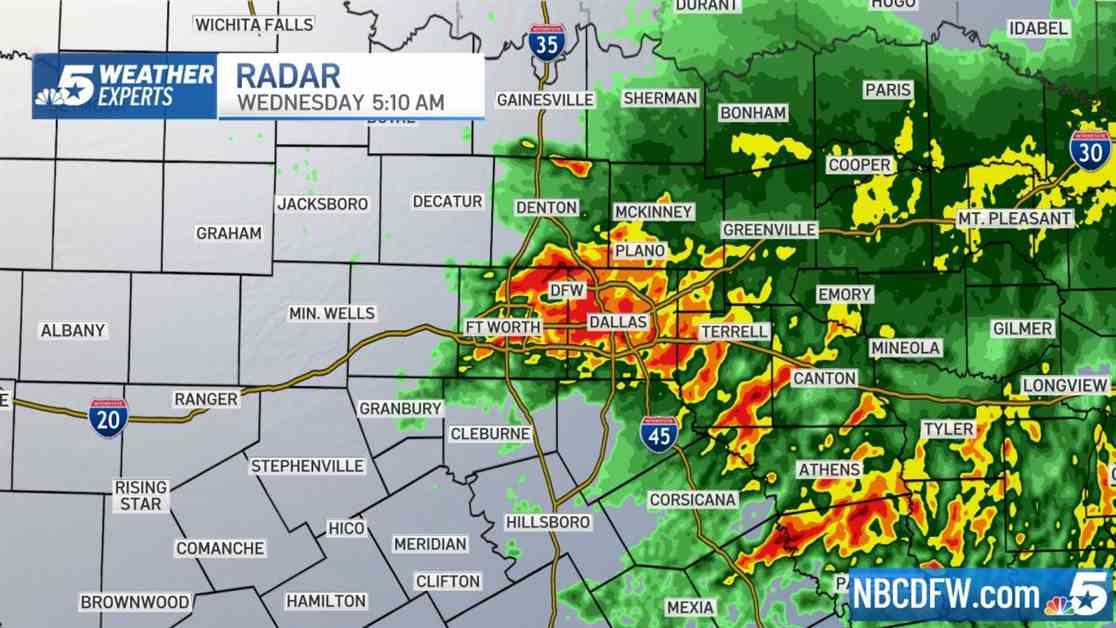
LIVE RADAR: Severe Thunderstorm Warning and Flash Flood Warning as storms move in to North Texas
Storms dropping down from Oklahoma are bringing very heavy rain, strong winds and a threat for flooding to North Texas. The National Weather Service has issued a Severe Thunderstorm Warning until 5 a.m. for Anderson and Henderson counties. The main threats are **60 mph wind gusts** and **nickel-size hail**. A Flash Flood Warning has been issued for Collin, Cooke, Fannin, Grayson and Hunt counties until 6 a.m. and for Collin, Dallas, Denton, Kaufman, Rockwall and Tarrant counties until 8 a.m. The line of sub-severe storms is bringing torrential rainfall and **wind gusts up to 50 mph** to Collin, Dallas, Denton, Rockwall and Tarrant counties. A Flood Advisory has been issued for Collin, Dallas, Denton, Hunt, Kaufman, Rockwall and Tarrant counties, you can expect ponding on area roadways and minor flooding in low-lying areas and areas with poor drainage. Remember when you see water on the road — **turn around, don’t drown**.
Several North Texas counties are under a **Flood Watch** through 10 a.m. Wednesday morning. One to three inches of rainfall could fall in this area. Please remember your **flash flood safety tips**.
The pattern we have been stuck in for the past two weeks is what’s called a **”northwest flow.”** This is where the upper-level winds (near the jet stream) come from the northwest. This means that when storms develop over the Western High Plains (Texas and Oklahoma Panhandles and western Kansas) they get caught up in the jet stream and are pushed down into our region.
While this pattern has been more active than usual, it’s a pattern that’s typical for this time of year. Without a doubt, this has been a very active spring storm season. The almost 10 inches of rain we have received since the start of May has been well above normal, but not enough for a record. From Jan. 1 through June 2, the precipitation we’ve received ranks in the Top 10 for the entire year. Below you can see 2024 ranks in 6th place. For some perspective, typically we average just over 37 inches of precipitation for the entire year.
Overnight showers and thunderstorms will push out early this morning. Before they end, a **flooding threat** continues. Be on the lookout for high water on the roads. The rain should be over by mid-morning.
