
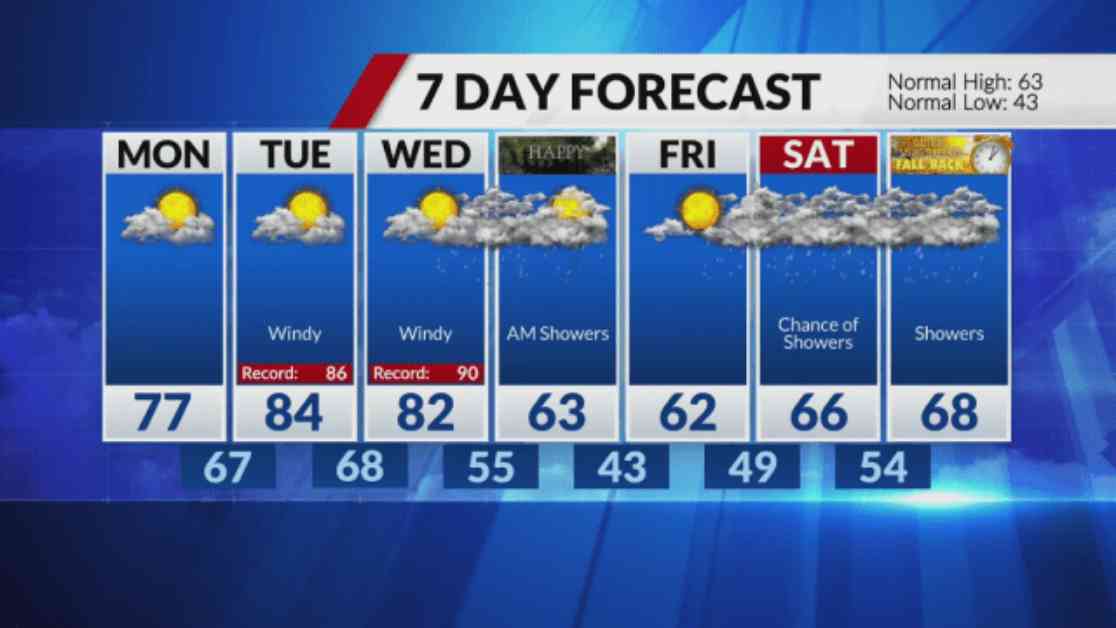
Today started off a bit cold, but the temperatures are expected to be a bit warmer compared to Saturday. We can expect temperatures in the mid to upper 60s along with clear skies. However, changes are coming starting from Monday as warmer air moves into our area. Monday will see highs in the upper 70s. Additionally, the winds will pick up in the afternoon on Monday and will be even stronger on Tuesday and Wednesday.
The temperatures on Tuesday and Wednesday are expected to reach the 80s, with Tuesday being the warmer day of the two. It’s important to be cautious on Tuesday as there may be an increased risk of fires due to the combination of gusty winds, dry vegetation, and low humidity levels. So, it’s crucial to stay vigilant and take necessary precautions.
By Wednesday night, our area will be impacted by a storm system and a cold front, bringing with it rain and the possibility of a few thunderstorms overnight and into Thursday morning. The good news is that the rain is expected to move southeast by the afternoon, giving hope for a rain-free evening for those planning to go trick-or-treating. However, the temperatures will drop significantly starting from Thursday, with highs back in the 60s.
Looking ahead, there are chances of rain over the weekend on Saturday and Sunday. The exact timing and location of the rain are still uncertain, so it’s essential to stay updated on the weather forecasts as the weekend approaches. Make sure to plan your outdoor activities accordingly and have a backup plan in case the rain decides to make an appearance.
Overall, the weather forecast shows a mix of warmer temperatures, windy conditions, and chances of rain throughout the week. Stay informed, stay prepared, and enjoy the changing weather patterns as we transition into a new season.